Delaware River
The Delaware River is a fairly long river which separates first, the states of New York and Pennsylvania, and then further downstream, the states of Pennsylvania and New Jersey, before finally dumping into the Atlantic Ocean just south of Cape May, New Jersey. It is also the main commercial shipping route into the port in Philadelphia. While there are many small areas along the extent of the river, which are navigable, or semi-navigable, I am limiting this review to the last continuous stretch of navigable water which runs between Trenton NJ, and the ocean. Above Trenton the water becomes shallow and rock infested, so most of the larger boats run south from there. Because of the commercial shipping interests, the river has a dredged channel which is normally in the 40' depth range. Click here for a map of the area. For more information on the river itself, click here.
There are many boat ramps situated along both sides of the river. Some are public, and others charge a nominal fee. I have had the most experience with the ramp at the Neshaminy Creek park area, which is north of Philadelphia. There are really 2 different ramps here. One dumps directly into the main body of the river. Since the river is tidal, this ramp can get tricky in a low tide situation and you may have to run though mud to get to the water (A 4X4 is a necessity). The other ramp (known locally as "Jack's") is better. This one dumps into a sheltered, man-made lagoon adjacent to the mouth of the Neshaminy Creek, but not physically attached to it. The lagoon was dredged back in the 90's, which removed much of the shoaling which had formed along the inside of the seawall, and had made navigating a little tricky at low tide. The launch ramp itself is large, and 3 or 4 boats can launch at the same time. It does get a bit crowded on weekends, so an early start is advised. See an aerial photo of the ramp complex here.
Just to the north of the Neshaminy ramp on the New Jersey side, is Burlington Island. This island has a colorful history and was once home to an amusement park, which was destroyed by a fire in 1928. Today, nothing remains of the park but a large 100 acre water-filled "pit". On the "Jersey" side of the river adjacent to the island, is a bar and grill where you can tie up and have a snack or two. It's also home to the New Jersey state police marine patrol.
All along the river are various marinas, and associated facilities, way too numerous to mention. On the Pa. side, there are also remnants of the industrial age, including the former U.S. Steel plant in Fairless Hills, as well as docks which were used to unload coal, and other raw materials. There are also a few bridges which span this part of the river between Pa, and NJ. Two of them are drawbridges, known as the Burlington-Bristol bridge to the north, and Tacony-Palmyra bridge further south, and within the city of Philadelphia. If you are into a more scenic landscape, head in a generally northerly direction. The New Jersey side is mostly scenic. There are a few eyesores on the Pa side, including a rather large landfill, which affects the nose as well as the eyes.
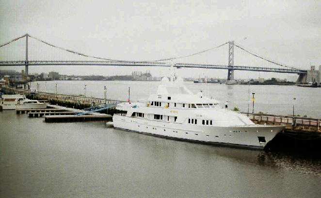
Heading south toward Phila, Pa, and Camden, NJ., the area becomes increasingly more industrialized and urban in nature. On the New Jersey side there is the Rancocas Creek, a tributary creek which is navigable to motorboats for a few miles upstream, and is a favorite for canoeists further upstream. The skyline of Philadelphia is impressive from the water, especially at night. Just downstream of the Ben Franklin Bridge, on the Phila. side, is Penn's Landing. Penn's Landing is the focal point for many musical and cultural activities. It is also home to Admiral Dewey's flagship, the Olympia, and a submarine. It is also the home to the Spirit of Philadelphia riverboat dinner and sightseeing cruises. Below is a view from the upper deck of the Spirit, looking north toward the Ben Franklin Bridge, just before departure:
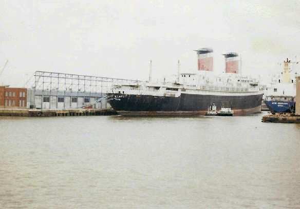
A little further south, and you come across another piece of nautical history, The S.S. United States. This 990 foot ocean liner was launched in 1952, and still holds the record for the fastest transatlantic ocean crossing. Unfortunately, it's been in a state of disrepair, and a victim of an uncertain future. For more information on the S.S. United States, click here. Here is a picture of "The Big U", which I took during one of my outings:
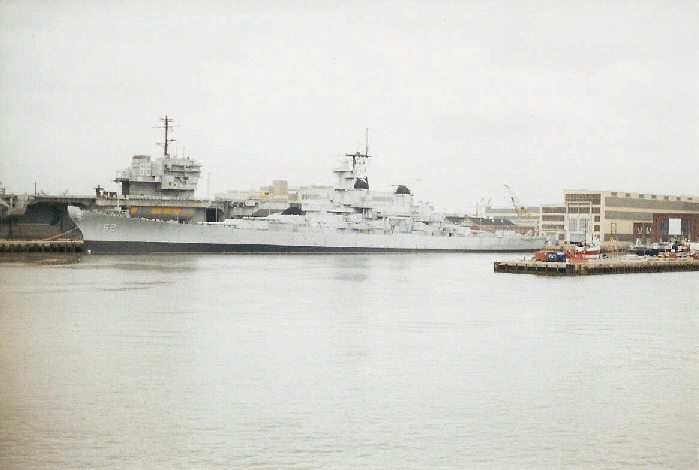
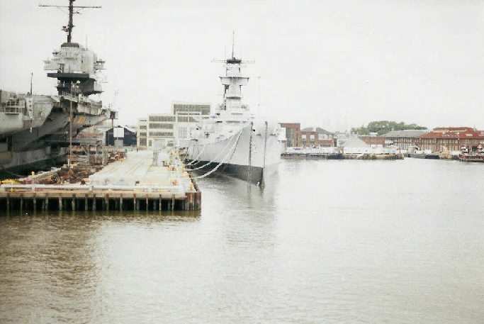
Further south, after passing under the Walt Whitman bridge, you will come across the former Philadelphia Naval Shipyard. Located at the point where the Schuylkill River dumps into the Delaware, the "Navy yard" was a dry dock facility which had served the navy for many years, and was also home to the mythical "Philadelphia Experiment". In recent years, due to cutbacks in the military budget, the facility was closed. Although there were still a few mothballed ships still hanging around the last time I was there. Below are two pictures of the Battleship New Jersey, when it first returned to this area. It was temporarily moored at the Navy yard, before being towed to its final home as a tourist attraction along the up-and-coming Camden NJ waterfront:
Further south and you pass by the Philadelphia International Airport. Watching large jets fly directly over you during departure and approach can be a little uncomfortable though.
The river continues on south until it eventually makes it's way to the Atlantic ocean. I haven't made the trek further south from this point, but I have been in the area around Delaware City, and the entrance to the Chesapeake and Delaware Canal. I often use the public launch ramp in Delaware City, as my gateway to the Chesapeake Bay, but I've checked out some of the local Delaware river scenery as well. The most noteworthy attraction in the immediate area, is Pea Patch Island. Home of a Civil War prisoner of war camp, it's now a state park and tourist attraction. Boaters attempting to circumnavigate Pea Patch island need to be aware of a semi-submerged stone wall, which extends out from the northern side. There are places in the wall, which allow passage, but they can be hard to see, especially at high tide, and it doesn't take much imagination to contemplate what would happen if you hit the wrong part at speed.
Since I am not a big fan of salt water, I have not ventured any further south on the Delaware River. To be honest, when compared to the Chesapeake Bay, and it's many tributaries, the Delaware falls short on the scenic appeal scale. The Delaware was clearly more of a "working" river, than a scenic one.
Pros: It's a fairly long span, which gives the avid cruiser some good ground to cover and some scenery to travel by. There are also many places to visit, from both a historic, and a cultural standpoint.
Cons: There is a good amount of traffic, both recreational and commercial, which makes for a good amount of chop on weekends. The river is tidal, and some ramps get a bit tricky during low tide. There is also the potential for a significant amount of floating, or semi-submerged debris, especially after a rainstorm. It's also no longer a convenient travel distance for a day trip from where I live now.