Schuylkill River
One of the first things you have to learn, is how to spell it. Then you have to learn to pronounce it. Once you're gotten over those initial hurdles, you can go on to explore the interesting parts. The Schuylkill River (pronounced "Skool-Kill") is a long and winding river, which flows through at least 5 counties in Pennsylvania before finally dumping into the Delaware River just below the former Naval Shipyard in Philadelphia. In some places the river is scenic, in some places shallow, and in other places it's just deep enough to boat on. The river also has some historic appeal and significance, as it was used as a commercial waterway for transporting coal from the mines in north and central Pa., as well as other goods into and out of Philadelphia Pa. in the 18th and 19th centuries. Parts of the river have adjoining remnants of a parallel canal system, which had been constructed to cover the less navigable parts of the river. There were also locks and dams in several places, most of which are long gone now. The dams which still remain, are used for mostly flood control, or are maintained to provide a navigable pool for recreational opportunities. Such is the case for the approximately 4 mile stretch of the river between the dam below the route 202 bridge in Norristown, and the Betzwood section of Valley Forge Park. The dam was created as part of the old canal system, and provided the navigable pool for the canal boats, before herding them into the Norristown section of the canal, which ran through the present town of Bridgeport. This is the place that we called our home port for several years. Click here for a map of the area.
There are two public launch ramps, each located at the extreme opposite ends of the navigable section. One is located in what's known as "Riverfront Park", off of Haws Ave. in Norristown. The ramp is finished concrete and there is an adjacent concrete dock to tie up to, although you may have to "shoo" away some of the locals fishing from there in order to make room. The parking lot is small and the parking spaces are not marked, which results in a tendency for people to park haphazardly all over the place, which further restricts usable trailer parking space. The other public ramp is located adjacent to the route 422 bridge, in the Betzwood section of Valley Forge park. This ramp is also finished concrete, but it has no dock. You are also required to detach your trailer and park it in a special "trailers only" lot, and then park your tow vehicle in the regular car lot. This is a bit of a hassle, which is why I haven't used this ramp since I had a small boat. There are also a few private ramps along the stretch. One belongs to the Norristown boat club, another belongs to the Commercial club. There are also ramps at most of the homes, which line the north shore in a little community called Port Indian. The river floods fairly frequently, so I have to question the sanity of the people who live there. Even when set on raised blocks, these homes, and their yards, are often exposed to serious flood waters at least every 2 or three years.
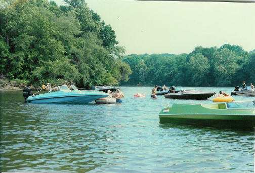
Navigating the Norristown section of the river is a bit tricky for a first timer (and even for seasoned river boaters). The depth ranges from mere inches in a few spots, to about 10 or 11 feet in some of the deeper holes. There are also a few unmarked "shoals" which you need to be aware off, in order to avoid the pitfalls of finding yourself in too shallow of water to run in. Since these areas are not marked, the only way to find out about them (other than the one which will result in costly damage) is to hang out with a local who knows the river, or proceed slowly with a depth finder (or a long pole) and "map" it yourself. As you head upstream from the Haws Avenue ramp, (You don't want to go downstream, unless you're fishing AND know the river well) you need to stay in the center initially and then slowly head over toward the right side after about a 1/4 mile, as the left side becomes less than 2 feet deep here. At this point you are also adjacent to the point of Barbados Island, which lies in the middle of this section of the river and is also home to a mothballed electric generating facility. Our local group, who I refer to as the "River Rats", generally anchor at the tip of this island in the 2 or so feet of water depth, and hang out.
You never know what kind of crazy looking boats you might see during an afternoon outing at "the river"........
You can head around the island (Making sure to clear the shoal at the tip) and head down the other side. The river is deeper (Probably the deepest of the whole stretch) on the other side of the island and is a favorite spot for water skiers, tubers, as well as the local scullers who have a clubhouse there. It is also possible to completely circumnavigate the island, but it is tricky, places you dangerously close to the dam at one point, and serves no real purpose other than to appease curiosity. Once you start upstream past the island, you can continue up the center of the river for another mile or so. At this point you will reach the remnants of a former lock and dam, known locally as "Catfish Dam". The Army Corps of Engineers allegedly removed the dam, but they never cleared the river completely. Consequently, there is only a narrow navigable channel through this section, which is usually marked during boating season, but occasional floods may move or totally remove the buoys. To make matters even more confusing, the channel is not straight through, but rather a diagonal course, running from the south side to the north side, as you head upstream. Failure to stay in the channel will result in you finding yourself in inches deep water filled with hard rocks, and a mangled prop, at a minimum, is a certainty. Upstream, beyond Catfish Dam, you have another "safe" area to run in until you get to just upstream of the Betzwood ramp. About 1/4 mile further upstream from Betzwood and you again run into shallows, and boats bigger than aluminum fishing boats generally don't go upstream any further.
Pros: Until I moved in 1999, this was less than 4 miles from my house, which made for a quick and easy trip, even after a hard day at work. It's also a good place for skiing and tubing, as long as it's not too busy. It was also a great place to hang out and socialize. On many days, we would just anchor at the tip of Barbados island and party. As the price of gas continues to climb, this was a good way to enjoy boating without having to run all that much.
Cons: It's a fairly narrow river, which makes it a bit tricky to cruise on the more crowded weekends, so you have to remain alert. The numerous shallow areas also make it a bit risky, even for those of us with years of experience under our belts. The regular floods also bring semi-submerged logs and other temporary hazards, which you need to remain on the lookout for. The river is also not a very long run, and once you get used to a bigger body of water, like the Chesapeake Bay, this seems like floating in a bathtub by comparison.